


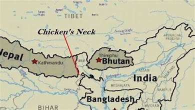
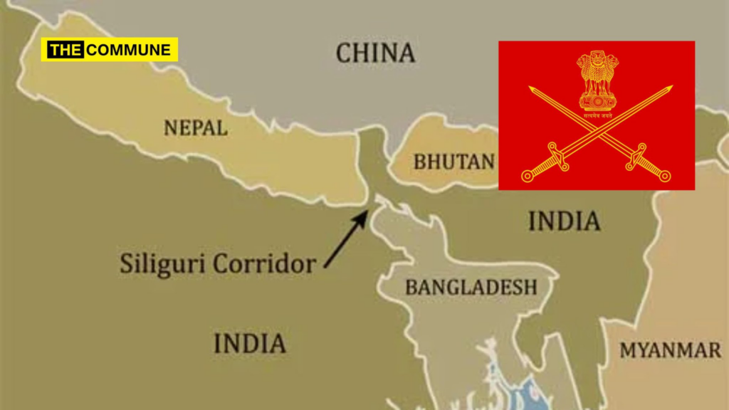
Let’s talk about “India’s Chicken Neck” – a fascinating place known as Siliguri, more than just a dot on the map. If you ever trace the political map of India, you might find your eyes heading towards the seven sister states of the Northeast, a secluded haven of distinctive cultures and scenery. But take a closer look at the connection between these states and the rest of the nation. You’ll see that there’s a narrow, almost fragile stretch of land in West Bengal sandwiched between Nepal, Bangladesh and Bhutan. This is called the Siliguri Corridor and, more famously, India’s “Chicken Neck”.
The Shape on the Map: How It Got Its Name
In addition to “neck”, there are also two other interpretations, which highlight the strategic value and the fragility of the region:. This is the only route by road linking the Northeast with India. This small strip of land is 20-22 km (12-14 miles) in the narrowest place. In the same way that the neck joins the chicken’s head to its body, it joins India.
The name “neck” also has other connotations which point towards the strategic importance of the region, namely fragility. It is the only land route that connects the Northeast with India.
A Colonial Legacy: The Birth of a Corridor
The Siliguri Corridor wasn’t always a strategic chokepoint. Its existence is a direct consequence of a pivotal moment in history:
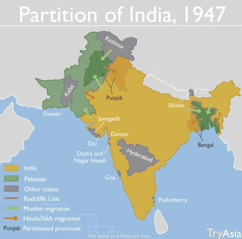
The Partition of India in 1947.
During partition, the province of Bengal was divided into West Bengal (which remained with India) and East Bengal, which became East Pakistan (now Bangladesh). The new border, drawn along religious lines, inadvertently created this narrow strip of Indian territory to maintain contiguity between West Bengal and the then-Assam region. What was once a seamless region became a defined and constrained passage, a “cartographic relic” of the decolonisation process. The subsequent independence of Bangladesh in 1971 solidified the borders as they stand today, with Bangladesh flanking the corridor to the south and east.
Surrounded by Neighbors
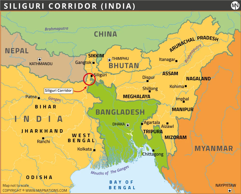
It has an international border with Nepal to the west and Bangladesh to the south and east. Bhutan and the Indian State of Sikkim are its northern boundaries. However, there’s another power standing behind Bhutan that’s more significant. Directly north of Bhutan is a southern finger of China (Tibet), the Chumbi Valley, which, like a dagger, protrudes into the region between Sikkim and Bhutan. It appears it would not be difficult for an enemy power to completely isolate the entire Northeast region, containing millions of citizens, by deploying a few soldiers—in theory.
The centre of illegal business transactions.
In addition to these immediate security threats, the terrain is such that the corridor is not easy to secure. An area with largely intact 30 per cent forest coverage, crisscrossed with many easily traversable international borders, is best for the transshipment of contraband and human smuggling. Cattle, gold, narcotics, and idols belonging to old gods – all come through these weak boundaries, and a place known as ‘Mechi Bridge’ at the Nepal-India border is quite known for human trafficking.
The ‘Blessing’: An Economic and Cultural Lifeline
However, to view the Chicken’s Neck only as a vulnerability is to miss the full picture. It is equally a zone of immense opportunity and activity.
Gateway to the East
This is the corridor upon which all important things travel. Every day there are a million trucks, buses and cars moving across the region, carrying approximately 2400 tonnes of cargo each day and creating large amounts of revenue. All food, medicine, and manufactured goods arriving in the Northeast from the “mainland” must squeeze through this bottleneck. This is not a road; it is a vein.
Center of Commerce
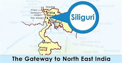
It is the central junction point not only of traffic of India’s internal movement but also of international movement traffic of Nepal, Bhutan and Bangladesh as well. This city is buzzing and expanding at a frantic pace, with logistics and trade taking precedence, followed closely by services. The oil and power pipelines, electricity cables and communication networks have all been compressed into the one corridor.
A Cultural Melting Pot
Cultural Melting Pot The meeting of the border also has meant the region has become something of a cultural melting pot. With millions of people in the corridor, there is a racial mix of Bengalis, Nepalis, Rajbanshis, Adivasis and Biharis, creating a unique mix of races, languages and food. The markets of Siliguri are testament to this mixed culture.
Securing the ‘Neck’: From Vulnerability to Strength
Since India has recognised the strategic importance of the corridor, it has been trying continuously to develop and strengthen it, in a way transforming a liability into an asset.
Army Establishment:
The Indian army is always present as a dominant force. 33 Corps of the Indian Army (Trishakti Corps) is located close to Siliguri to secure this sensitive part. There have been three new army garrisons built up by India along the border with Bangladesh since 2014. New additions to the Indian armed forces include the addition of sophisticated weapons like the Rafale aircraft at the Hashimara airbase and sophisticated layered air defence, including the S-400 missile defence system.
Overhaul of the infrastructure.
The railway line which passes through this corridor is already electrified and has been doubled, and heavy infrastructures have been developed to make it much more viable. Amongst these, Indian Railways is planning to lay down a new underground railway track all over this corridor. The modern tunnel boring machines will facilitate building a tunnel network of 76 km, providing a constant connection and immunity from natural disaster. Leaders and strategic experts are also of the same opinion. In the words of a military officer, “Chicken’s Neck is turning into a tougher defence corridor” due to “the entire force being able to rush to this region”. That is rightly said by spirituality guru Sadhguru, “Nourish the chicken and let it be an elephant.”
Conclusion
But why does Siliguri go by the name ‘Chicken’s Neck’? This name describes the shape it is on a map, its only connection with the Northeast, and, of course, its weak structure. A place where frontiers are blurred, economies integrated, and cultures merge. A place which was a product of the 20th-century partition but continues to be an essential appendage to India. The Siliguri Corridor continues to be a fine balance between a geopolitical vulnerability and a lifeline, a thin corridor with the burden of a region upon it.